Without a doubt, Ordnance Survey is a British institution. They are the standard against which all other cartographers are measured, and we’d be surprised if there are any walkers or hikers who don’t have at least one OS map in their house.
Related: What To Do If You Get Lost When Hiking
We recently got the chance to speak with the lovely people at Ordnance Survey and quizzed them about a typical day at work, how their maps have changed over time and whether they’re ever tempted to sneak in a joke or two into their maps…
Is there a typical day for someone at OS?
In the sense that the business is working hard to keep 460 million plus features of Great Britain up to date, yes! But in terms of one typical day – not really. Away from head office, there are surveyors working on the ground dealing with everything from new housing estates to skyscrapers to football grounds; and our Flying Unit are in the skies capturing aerial imagery of a different part of Britain every day. On average that’s 50,000 aerial images covering 40,000 km squared of Britain’s urban, rural, moorland and mountain terrain every year.
Back at head office, those changes are processed by our Remote Sensing team who take the imagery sent through by the Flying Unit and use it to update our large scale topographic database. Then you have our Cartography team and our Product teams all working on changes and ensuring they feed into all of our products. It all adds up to over 10,000 changes a day being processed in our huge database of the master map of Great Britain, for use by government, businesses and individuals.
How often are the OS maps updated?
For our paper map products, there isn’t a ‘one size fits all’ answer. Generally, we’ll renew a paper map every three to five years, but the frequency depends on a number of factors. The primary one being the amount of change that needs to be applied to the map since it was previously revised. The popularity of the sheet is also a factor. A map covering an area popular with visitors such as the Lake District would take priority over a less-popular area, providing, of course, that changes have occurred that would be important to the users – new footpaths, roads or a visitor centre for example.
Related: How Wearable Tech Is Transforming Hiking
However, changes are made in our database every day and for digital data products delivered to business and government customers, they could see changes as frequently as every six weeks, depending on the products they’re using.

How do you actually go about creating an OS map? There's so much detail!
The map making process has changed dramatically over our 225 year history, since the days when cartographers painstakingly drew and carved each individual feature by hand. The advent of computers meant that we started digitising our maps in the 1970s and completed the process in 1995. Our Cartography team is really lots of separate teams with different specialisms, and they are responsible for deriving and maintaining cartographic databases, and providing the finished data for Ordnance Survey national series paper and data products. They do this through the manipulation and enhancement of our core databases.
Aside from the standard maps, could you explain a little about your other popular services?
While our much-loved maps remain an important part of our brand, they represent only 5% of our annual revenue. We produce digital map data, online route planning and sharing services and mobile apps, plus many other location-based products so you know exactly where you are.
In the leisure map world, we have a series of online and mobile services to complement the paper maps. From 24 February, all of our OS Explorer and OS Landranger paper maps will come with a mobile download. Available for iOS and Android, the downloaded map on our OS Maps app lets you plot and store routes electronically with the map data stored locally and available regardless of whether your smart device has a signal or not. This makes it perfect for even the remotest of areas to use alongside your paper map.
Related: The Hiking Gear You Need To Survive The UK Weather
OS Maps is also available as an online service as a complete tool for outdoor adventure. You could use it to plan a long weekend exploring a National Park with a map print and the route on your GPS device, or you could try over 500,000 existing routes and adjust your preferences to find out how long each route will take you to walk, run or ride.
We see OS Maps online and mobile as being the best way to complement a paper map and give you ease of use, while still having the paper map back-up to keep you safe.
Can the public get in touch if they notice a mistake or want something including on a map?
Yes, you can contact our Customer Services team if you spot something that has changed and they will log it to be investigated.
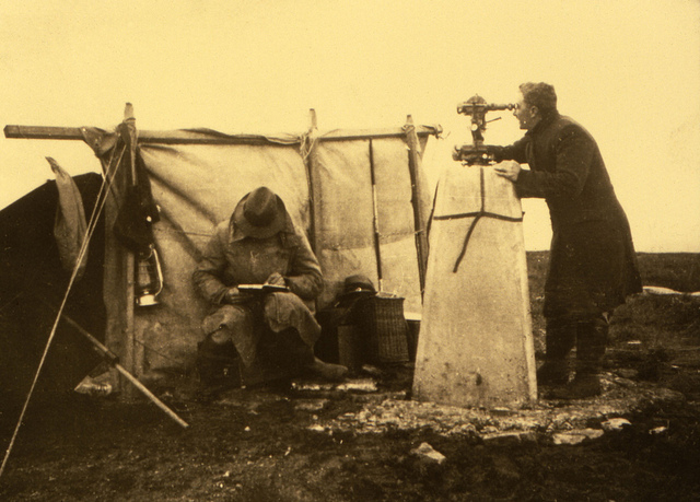
Historical image of OS cartographers
How has OS changed as technology has evolved over the years?
We’ve changed from a centuries-old venerable mapping company into a big data powerhouse. Our location information is weaving itself into the very fabric of our everyday lives, right across Great Britain.
In total, we’ve logged 460 million individual geographical features including over 35 million buildings and over 27 million residential addresses. Accurate location data will improve decision-making and planning for any business or government, no matter what its size or activity.
Related: Exclusive interview with Nick Hancock of the Rockall endurance expedition
And of course, we still invest in our paper maps, such as the recent move to include a mobile download with each copy bought.
Do you think there's still a demand for paper maps?
Yes! Over the last couple of years we’ve seen a growth in the number of paper maps being sold. Paper maps are used by millions of outdoor enthusiasts every year, enabling people to get outside and explore and enjoy Great Britain. Our paper products remain an important part of Ordnance Survey with almost two million sold over the last year, and an increase of 1% in numbers sold.
Have you ever been tempted to sneak little secrets or jokes onto the maps?
We pride ourselves on the accuracy of our paper maps, but we have heard of cartographers in days gone by managing to hand-scribe their names into detailed areas of cliffs and so on!
Today, with the incredible level of detail shown in products such as OS MasterMap Topography Layer, where the location of every road, every kerb, every wall, house or address – everything – has been recorded, and is relied on by businesses across Britain, it would be very difficult to do anything similar.
Obviously you are pretty spot on with the mapping, but in the past have you ever got it seriously wrong?
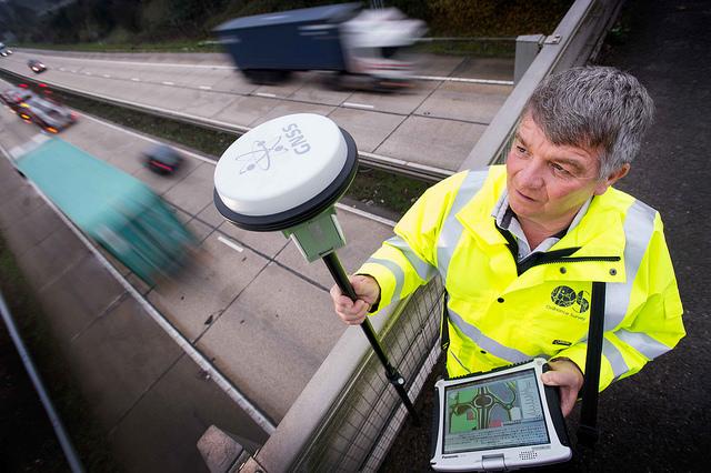
When we look back at our history and the work carried out by surveyors and cartographers, it’s amazing to see just how accurate their measurements and drawings were. The amount of work involved in creating a definitive map of Britain without today’s GNSS and computer technology is just staggering and we remain in awe of their efforts.
Do you still use Ordnance Survey maps? Learn more about the fantastic work OS do over on their website.


1 Comment